
_0%20(1).jpg)
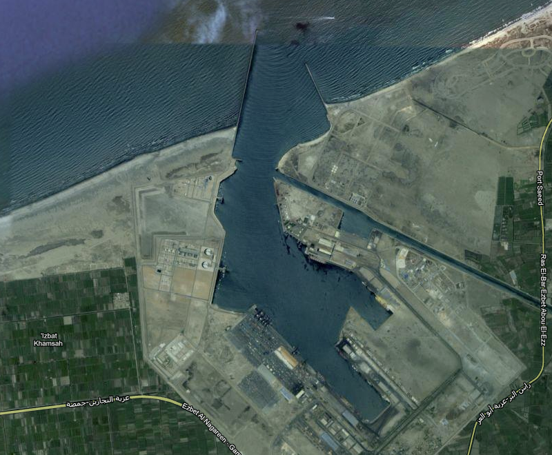
Damietta (EGDAM) Port The Port of Damietta is an ancient city that lies on the east bank of the Damietta branch of the Nile River in Egypt. The Port of Damietta is about 40 nautical miles (56 kilometers or 35 miles) northwest of Port Said and about 112 nautical miles (184 kilometers or 114 miles) east-northeast of the Port of Alexandria. When the Mahmudiyyah Canal was built in 1819, much of the Port of Damietta's trade was diverted to Alexandria. Almost 77 thousand people live in the city and Port of Damietta.
PORT LOCATION
Latitude 31° 28' 0" N
Longitude 31° 45' 52" E
Time Zone Africa/Cairo
Port security Level : 1 (One)
- Water Depth Channel: 46 - 50 feet 14 - 15.2 meters Cargo Pier: 41 - 45 feet 12.5 - 13.7 meters Mean Tide: Anchorage: 46 - 50 feet 14 - 15.2 meters Oil Terminal:
- Lifts & Cranes 100+ Ton Lifts: 50-100 Ton Lifts: 25-49 Ton Lifts: 0-24 Ton Lifts: Fixed Cranes: Mobile Cranes: Floating Cranes:
- Port Detail Port Authority: Damietta Port Authority Address: PO Box 13 Damietta 34511 Egypt Phone: 2057-325940 Fax: 2057-325930
- Harbor Characteristics Harbor Size: Large Maximum Vessel Size: Over 500 feet in length Harbor Type: Coastal Breakwater Turning Area: Yes
The Port of Damietta is a medium port in Egypt. See below for a live map of ship positions in Damietta, schedules for vessels arriving (port calls), the list of ships currently in port, a company register and a local weather forecast. Damietta's LOCODE is EGDAM.
Pilotage is compulsory. Pilotage charges are consistent with decree 60/1988 (concerning Egyptian vessels) and decree 73/1988 (concerning foreign vessels). Transshipment Containers are accorded 20-50% reduction according to decree 40/1990. Container carriers transiting the Egyptian ports are accorded 75% reduction.
Details of Berth
| Berth No | Permissible Draft (M) | Length (In M) | Type of Berth |
|---|---|---|---|
|
|
|
|